Launches
Coming soon
Upcoming launches to watch
Launch archive
Most-loved launches by the community
Launch Guide
Checklists and pro tips for launching
Products
News
Newsletter
The best of Product Hunt, every day
Stories
Tech news, interviews, and tips from makers
Changelog
New Product Hunt features and releases
Forums
Forums
Ask questions, find support, and connect
Streaks
The most active community members
Events
Meet others online and in-person
Advertise
Subscribe
Sign in
Postcodeheatmap
Turn your spreadsheets into beautiful map visualizations
•
0 reviews
•
12 followers
Visit website
Follow
Overview
Launches
Reviews
Team
More
Blog
•
Newsletter
•
Questions
•
Forums
•
Product Categories
•
Apps
•
About
•
FAQ
•
Terms
•
Privacy and Cookies
•
X.com
•
Facebook
•
Instagram
•
LinkedIn
•
YouTube
•
Advertise
© 2025 Product Hunt
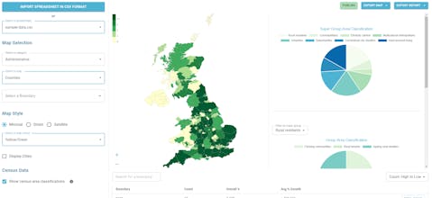
What is Postcodeheatmap?
A super simple tool to visualise your customer density across UK geographic boundaries such as counties and regions. Just upload a spreadsheet of postal codes and then export your heat maps as images or generate reports.
Do you use Postcodeheatmap?
I use this
I use something else
Data analysis tools
•
Data visualization tools
•
Business intelligence software
Recent Postcodeheatmap Launches
Postcodeheatmap
Turn your spreadsheets into beautiful map visualizations
Launched on March 5th, 2024
1
64
Postcodeheatmap Alternatives
doodooc Music Visualizer
29 reviews
Video editing
Visualize Habits
6 reviews
Work & Productivity
Review Postcodeheatmap?
Leave a review