Displays elevation and/or sea depth (terrain/elevation profile) in direction of phone. Useful for hiking, trekking, mountaineering and fishing. * 5km range * ele. pts every 10m/100m horizontally * directions rounded to 30° steps
Recent launches
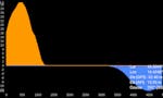
Elevation and Sea Depth
Displays elevation and/or sea depth (terrain/elevation profile) in direction of phone. Useful for hiking, trekking, mountaineering and fishing.
* 5km range
* ele. pts every 10m/100m horizontally
* directions rounded to 30° steps
Elevation and Sea Depth
Displays elevation and/or sea depth (terrain/elevation profile) in direction of phone. Useful for hiking, trekking, mountaineering and fishing.