

What is Felt?
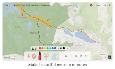
Felt makes it easy for anyone to create and share maps that tell a story — from campsite directions to shifts in climate. For the dozens of industries that rely on maps to get work done, Felt is the first user-friendly, collaborative tool built for teamwork.
Do you use Felt?

Recent Felt Launches

Felt Reaches 1.0, Now Ready for Teams Online mapping tool built for teams
Launched on February 28th, 2023


Forum Threads


Felt Reaches 1.0, Now Ready for Teams - Online mapping tool built for teams

Introducing Felt 1.0 — a new suite of tools for organizations to stay aligned with maps. Felt’s new pro features include Team accounts, Team Libraries and a vector rendering engine that will make your data shine. Create a team today!
Felt Alternatives
View all Felt alternatives


Review Felt?
4.89/5 based on 9 reviews
Reviews

•6 reviews
sii es genial me encanto nos divertimos mucho totalmente recomendado


•1 review
Felt is the collaborative map-making tool I want to use for everything I can. I'm a GIS nerd and contributed a lot of microPOI to OSM in my locality, but those maps never felt actionable the way I wanted them to be; taking screenshots and marking them up only goes so far. Whereas before I had to use something like a POI collection in Apple or Google Maps, Felt lets me instantly get my thoughts down and get a spatial understanding of whatever it is I’m trying to plan out, then share that with others easily.
In terms of features, the clipping tool is brilliant as an annotation device because it’s so simple but so helpful. The UI is immaculate and the collaborative nature of the service reminds me of something like a geospatial FigJam. Being able to upload images and georeference them on top of the overlays you’ve already got going is so useful for showing things on the ground.
Felt is my favorite map data tool and it's already helping me reduce my desire to learn something complicated like QGIS or pay a huge fee for something like ArcGIS. I absolutely recommend it to anyone looking to get something spatial done.


•2 reviews
Easy to create a new map and gives clear visual representation for what I was hoping for.